Total Mileage: 19.7
Route: Twentymile trail ( 3.1) to Long Hungry Ridge Trail (4.6) [possible side trip to Doe Knob at AT intersection-- 4 miles roundtrip], Gregory Bald trail to the Bald (1.2), stay the night at campsite 13. Day 2: Wolf Ridge trail back to 20mile ranger station ( 6.8).Sam has already blogged about the outting, so I'm going to steal his assessment...
Happy Trails
This weekend marked a momentous occasion, one rarely seen nor experienced during the tenure of my friendship with Andy "Scat Man" Lombardo. (By the way, that's his trail name due to his experience identifying various wildlife by their "gifts" on the trails. Mine is Sole Man. On a hike a few years ago, both my boot soles fell off completely and I had to hike one soled for 12 miles, and without any soles for another 4 when the left one fell off.) Anyway...the occasion is... we backpacked this weekend and stuck completely to the itenerary and pre-planned mileage without getting lost, adding 5-10 extra miles, or being flood bound.
We did the following:
Depart Maryville approx. 7am Thursday
Park at Twentymile Ranger Station off 129 past deals gap
Twentymile trail (3.1) to Long Hungry Ridge Trail (4.6), side trip to Doe Knob (4), Gregory Bald trail (1.2), stay at campsite 13, Wolf Ridge trail ( 6.3), twenty mile trail to ranger station (.5). Back in communication by sundown Friday.
It was reasonably chilly Thursday morning, but more so once we got to the ranger station. We planned accordingly by making the traditional Hardee's carbo load, and me swilling coffee from a Thermos from the moment I left my house until we were locking the car heading up the trail.
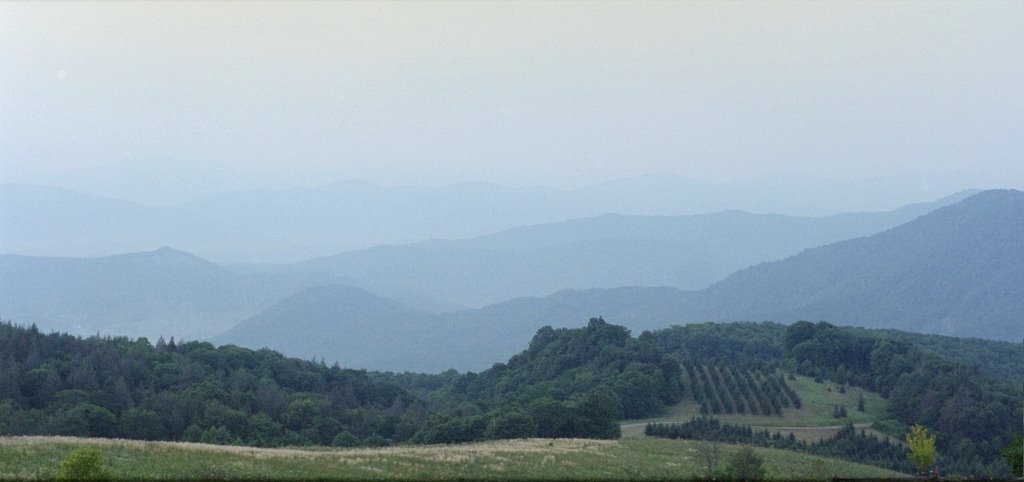
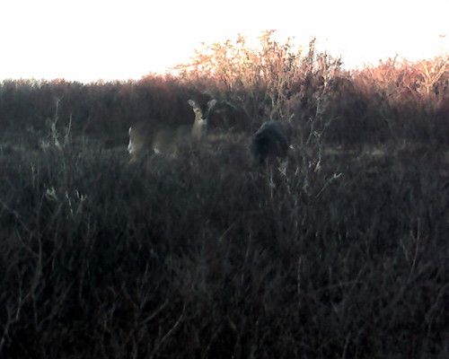
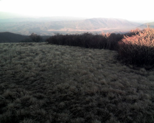
The Twenty Mile trail was moderate in grade as it was actually an old railroad bed. Once we started up the Long Hungry Ridge Trail it started to steepen quite a bit. From the very beginning and about every 30-50 feet we saw bear droppings, but we never saw any bear. This has to be the most bear activity I've ever seen in one place. We saw a wild boar sow and leopard piglet run up from the valley we were walking above. Believe it or not that is actually the most dangerous animal you can come across while in the Smokies. The sows are very protective of the piglets. No issues with this pair though. We decided to top off our water at a natural spring a half mile from the trail intersection. I had my Pur water filter all ready to go, but after 14 years of use, it finally died. I tried to repair the seal between the pump handle and O-ring with some chap stick, but alas we had to use iodine tablets. As is, I think the water would have been mostly safe, but my intestines are happy we used the tablets. We hit the Doe Knob intersection and hid our packs so we could do the detour trail to Doe Knob a bit less encumbered. Definitely a good idea as Doe Knob was a series of very steep ridge caps. We headed back to the packs we had stashed behind a big downed tree and when I was about 50 yards away, I heard a low grunt or growl. It was loud enough to make me stop, and then I just heard a faint snort and nothing else. Being the hardened backcountry man I am... or an idiot.. I pulled out my 3 inch pocket knife and headed toward the packs... ready for action! Let me mention this knife was a groomsman gift from a wedding I was in and had my initials engraved on it... not a serrated hunting knife. When I got there, nothing was within sight, so whatever it was moved out before I could get anywhere close. I could take this time to side-track on a notion I've had for years.. so here it goes. Somehow on one of the hikes or backpacking trips I have taken with Andy the discussion of hunting came up, and though I've never hunted, I thought the best way to get into the "sport" would be to truely match man to beast on fair ground. No guns, no bows, up close and personal. While I lack the teeth and claws or hooves to make it a fair fight, I think a knife would be equitable equipment. As conversations like these tend to escalate into the extreme, I decided the best way to hunt a deer is to drop out of a tree with a knife and wrestle it to the ground... naked. For a bear or a wild boar, I'd opt for a loin cloth. Aren't we all glad I don't hunt. So, packs back on, we head up toward Gregory's Bald. As I come into the clearing of the bald I see three deer grazing right in front of me. I stop and they start to walk toward me a little. After taking a couple of pictures I walk on up the trail expecting them to dart away. They just keep grazing so I get about 20 feet away and take a few more pictures. Andy gets to the clearing about that time and I try to motion to him about the deer, but his glassses are fogged up. He walked right up to me and stops and I say "Deer." and point left. He says "Ah. Deer." This is the shortest conversation we've ever had. Outstanding scenery from the top of Gregory's Bald.
So, we head down from the Bald toward campsite 13 and setup camp as it was now getting toward dusk... and COLD. Andy gets the tent setup while I fill up our water supply at a nearby spring. We get our stuff unpacked for the night and start dinner. Andy is a backcountry chef genius! Armed with a food dehydrator, camp stove, and pre-cooking foresight, he created a masterpiece of hot delicious food. It was a turkey-chili-mac creation accompanied by loaded mashed potatoes. For an apertif we were treated to hot chocolate with a warming shot of whiskey. Absolutely outstanding. Unfortunately there was a fire ban in effect due to the dry weather, so with no fire to hang around we cleaned up and went to bed. The wind picked up and it got COLD. To save pack weight, we opted for a 8'x 10' tarp using Andy's hiking poles to hold up the two ends. I had my zero degree mummy bag and Thermarest pad, and the area we setup the "tent" was very smooth and level. I think this was the first time my bag was perfect for the weather. I didn't freeze, I wasn't too hot. We got up kind of late and due to a slight malfuntion with the stove, had warmish oatmeal. I had brought a percolator pot to make coffee in, and after we figured out the stove, the coffee boiled just as we finished packing up camp. Andy had cell phone reception and checked in with Jody his wife. She asked if we were getting rained on. Nope. She said it was heading our way. No sooner than he hung up, it started sprinkling. By the time we had the pack covers on and our rain gear, it was raining hard. So, not one to leave a perfectly good pot of coffee to waste, I proceeded to hike out with mug in one hand and coffee pot in the other. I did about a mile like this until I finished the pot. It was a good move. I will do it again. I may do this when I go to the mall. Time will tell. So to finish up, we did the last 6.8 miles back to the Twenty Mile Ranger Station in about 3 hours. We were both soaked by the time we got there, so after a quick change of clothes, we headed back. Awesome trip. Enjoy the pics.
Oh yeah, the link with the pics shows a campfire and above I commented how there was a ban on campfires. That wasn't ours. We passed a couple backpacking back out just before getting to campsite 95 (only 1.5 miles in). We get to the campsite and we see this lovely raging campfire. No tents. No one around. These two idiots just packed up camp and didn't put out their fire... at all. Andy and I, being the kind nature loving law abiding citizens we are, took out the cooking pot and with a stream nearby, put out their fire. It's people like these, that make Smokey the Bear necessary...but only bearly. Ha! Pun in yo FACE!
Date: 12-27 to 12-28-2007
Hikers: Sam'n'Andy
Hikers: Sam'n'Andy