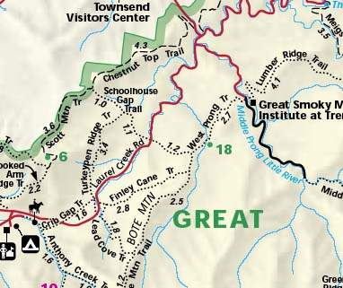
- Route: West Prong Trail to Bote Mtn Trail (2.7); Bote Mtn Trail to Laurel Creek Rd (1.2); Schoolhouse Gap Trail to Schoolhouse Gap (2.2); Schoolhouse Gap Trail to Chestnut Top Jct (.2); Chestnut Top to Townsend Wye (4.3). Piggyback: From Schoolhouse Gap Trail we took a .9 mile detour to White Oak Flats and then White Oak Sinks and back (.9 miles).
- Total Mileage: 12.4
- Time Table: 8am - 1:45pm
- Description: Trail from Tremont to Bote Mountain is about 1 mile up, 1 down, and 1 up again. From Bote Mtn Trail to Laurel Creek road is gentle downhill on a wide, hard packed trail. Schoolhouse Gap is a gentle uphill on a wide, hard packed trail. Schoolhouse Gap Trail continues to the park boundary and the trailhead for Scott Mountain Trail, where there is a small cottage and gravel road leading into Dry Valley. Backtracking to the Chestnut Top trailhead, Chestnut Top follows Chestnut Ridge 4.3 miles to the Townsend Wye. There is considerable downhill on this section, and a lot of elevation is lost, so it get's a little steep at times.
- Points of Interest: Side trail to White Oak Flats and White Oak Sinks
- Wildlife: Coyote, Deer scat; lots of Deer tracks on Schoolhouse Gap above Turkeypen Ridge trailhead.
Date:12-17-2005Hikers: Dave, Steve, Andy (2nd meeting of the IHC)